Edit a grid mask using Jupyter
A jupyter notebook was written for editing the ocean mask for a model grid.
The first step is to load the ocean mask for a model grid.
# Import needed python modules
import os, sys
from gridtools.gridutils import GridUtils
from gridtools.app import maskEditor
import cartopy.crs as ccrs

# Define the model grid directory
# For existing MOM6 grids, this is often an "INPUT" directory
wrkDir = '/import/AKWATERS/jrcermakiii/configs/zOutput'
inputDir = os.path.join(wrkDir, 'INPUT')

# Create a gridtools object
grd = GridUtils()

# Read the ocean mask
oceanMask = grd.openDataset(os.path.join(wrkDir, 'ocean_mask_Example7.nc'))

# The mask editor requires 'lat' and 'lon' coordinates for mapping.
# For MOM6, the x and y dimensions are renamed to lon and lat
oceanMask = oceanMask.rename({
    'x': 'lon',
    'y': 'lat'
})
oceanMask = oceanMask.set_coords(['lon', 'lat'])

# Set a map projection for the mask editor
crs = ccrs.Orthographic(-140, 45)

# Create the mask editor
appObj = maskEditor(crs=crs, ds=oceanMask['mask'])
app = appObj.createMaskEditorApp()
display(app)
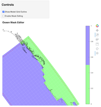
This will launch the map editor within the jupyter notebook.
When editing is complete, use and additional jupyter cells to save
the edited ocean mask variable oceanMask.
To keep this cell from running when starting the mask editor, the
runBlock is set to False. When it is time to save the new mask,
set runBlock to True and run the cell.
runBlock = False

if runBlock:
    # Save the new mask without coordinates
    newMask = oceanMask['mask'].copy()
    newMask = newMask.reset_coords(names = ['lat', 'lon'])
    grd.saveDataset(os.path.join(wrkDir, 'ocean_mask_new_Example7.nc'), newMask,
                    overwrite=True, mapVariables = {'lon': 'x', 'lat': 'y'},
                    hashVariables = ['mask', 'x', 'y'])